Highway 41 Corridor Improvements
 Skip to main content
Charleston County has been working to identify a solution to manage the growing traffic congestion on Highway 41. The project team has been following an environmental review process, which has included extensive public and stakeholder engagement as well as a detailed alternatives evaluation process to examine the environmental, social, cultural, and economic impacts of the proposed project. The purpose and need of the project are to reduce congestion within the corridor and accommodate future traffic projections.
From 2017 through 2021, many alternative concepts for the project were screened and either eliminated or moved forward for more extensive traffic and environmental review. As a result of those evaluations, Alternative 1 was presented to the public via a virtual public meeting in August 2020. This alternative recommended widening Highway 41 to four lanes through the Phillips community. Nearly 3,000 comments were received during the public comment period.
The project team presented a modified design to Council on March 4, 2021, that proposed widening Dunes West Boulevard, building a new four-lane road around Park West along the edge of Laurel Hill County Park, and limiting the Highway 41 widening through the Phillips community to three lanes instead of four. The modified design met the project's purpose and need. At Council's direction, this design was presented to stakeholders and the surrounding communities for review and input. The team held more than 20 meetings with stakeholders and community members along the Highway 41 and Highway 17 corridor to review the design in detail.
In response to community input, the project team developed a compromise for the surrounding communities. In August 2021, the Charleston County Council voted 9-0 to move the Compromise Alternative forward through the environmental review process and further into design. Since Council's direction, the project team has been developing design plans for submittal to SCDOT and submitted permit applications and supporting documentation to the U.S. Army Corps of Engineers (USACE) in May 2023 and South Carolina Department of Environmental Services (SCDES) in December 2023.
As of June 2025, the project design has been updated to further minimize impacts to wetlands and critical areas. Therefore, the permit applications, Environmental Report and supporting documentation were updated to reflect the reduction in impacts and were resubmitted to the USACE and SCDES. USACE and SCDES are currently undergoing their permit review processes.
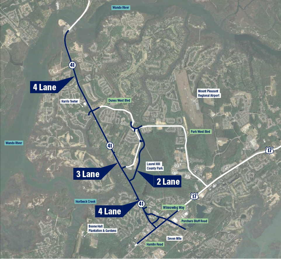
The Compromise Alternative consists of two travel lanes in each direction from the Wando River Bridge to Dunes West Boulevard/Rivertowne Parkway, one lane in each direction with a center turn lane/median through Phillips Community, two travel lanes in each direction from south of Joe Rouse Road to Highway 17, and adds a two lane southern parkway from Highway 41 to Park West Boulevard along the edge of Laurel Hill County Park. The Compromise Alternative also includes changes from earlier alternatives to reduce right-of-way impacts at the Highway 17 intersections with Highway 41 and Winnowing Way.
The project design has been updated to further minimize impacts to wetlands and critical areas. Therefore, the permit applications, Environmental Report and supporting documentation were updated to reflect the reduction in impacts and were resubmitted to the USACE and SCDES. USACE and SCDES are currently undergoing their permit review processes.
Next Steps
Interim improvements were evaluated by the project team to relieve congestion along the Highway 41 corridor until a final project is built. These improvements were evaluated for cost, traffic and feasibility and have been refined to avoid or minimize impacts on the surrounding area.
The existing signalized intersection at Joe Rouse Road and Highway 41 is approaching capacity and will continue to see increased congestion. The intersection was reconfigured to improve the flow of traffic and accommodate the increasing traffic volumes along the corridor. Changes were also made to the signal timing and minor construction occurred at the intersection of Highways 17 and 41 to provide additional traffic relief and significant reductions in delays for the entire corridor.
Also, two intersection equipment upgrades — funded by the County and installed by the Town — are being put in place as interim projects. One, at SC41 and Joe Rouse Road is complete, and the other, at SC41 and Rivertowne/Dunes West is underway.
The Compromise Alternative will impact both wetlands and floodplains within the project corridor. The County will be required to mitigate any wetland impacts associated with the project, and as the project is further developed, engineers will be required to address drainage to minimize or avoid impacts to these areas. Visit the project environmental process page for more information.
As part of the analysis process in the Environmental Report, properties that require right-of-way (ROW) acquisition have been identified. Preliminary ROW acquisition activities began in June 2025 and include title research and contacting property owners to explain the process and prepare appraisals. An appraiser will determine compensation for the ROW acquisition based on the value of the land being acquired and the project's impacts on the value of the remainder of the property. Once an appraisal is completed and final ROW plans are approved by SCDOT, the County can then contact individual property owners to begin discussions on the ROW acquisition.
The Project is designed to provide acceptable traffic flow in the morning and afternoon rush hours in the project design year. The project design meets the project purposes of easing traffic congestion, improving safety for commuters and will play a significant role in positively influencing the long-term transportation planning of Charleston County.
Enhancing safety throughout the project corridor is included in the Project Purpose & Need. The project team has been coordinating with SCDOT and the local County emergency management office on hurricane evacuation route requirements as the project has progressed. The project team will also include additional safety features for pedestrians and bicyclists throughout the corridor.
The Highway 41 Improvement project will include completing the Town of Mount Pleasant’s Gregorie Ferry Connector Road, which will tie into Highway 41 at Colonnade. In addition, Winnowing Way will be extended to Highway 41, providing a new connection from Highway 41 to US 17 at its intersection with Porchers Bluff Road.
Charleston County is leading the project in partnership with the Town of Mount Pleasant and South Carolina Department of Transportation. Cal Oyer, P.E., is the project manager for Charleston County.
The SC 41 Corridor Improvements Project is solely funded by the Charleston County sales tax. No U.S. Department of Transportation funding will be used for the planning, design, or construction of the project, and Federal Highway Administration is not providing oversight or approval. Because of this, review of the project under Section 4(f) is not triggered for the SC 41 Corridor Improvements project. However, the project team has evaluated potential impacts to Laurel Hill County Park and historic sites as part of our alternatives analysis.
Click for more details…
Section 4(f) refers to the original section within the U.S. Department of Transportation Act of 1966 which requires transportation agencies to consider historic sites and publically-owned park and recreation lands, and wildlife and waterfowl refuges during transportation project development. The law, now codified in 49 U.S.C. §303 and 23 U.S.C. §138, applies only to the U.S. Department of Transportation (U.S. DOT) and is implemented by the Federal Highway Administration (FHWA) and the Federal Transit Administration through the regulation 23 Code of Federal Regulations (CFR) 774. Before approving a project that uses Section 4(f) property, FHWA must determine that there is no feasible and prudent alternative that avoids the Section 4(f) properties and that the project includes all possible planning to minimize harm to the Section 4(f) properties. The project team has evaluated potential impacts to parks and recreation lands, including Laurel Hill County Park, as part of our alternatives analysis and coordinated with the Charleston County Parks and Recreation Commission. The team is also studying potential impacts to historic sites under the National Historic Preservation Act of 1966. If U.S. DOT funding is used on the project in the future, Charleston County would be required to review the project under Section 4(f).
Architectural and archaeological surveys have been completed for the SC 41 Corridor Improvements project, and consultation between the South Carolina State Historic Preservation Office (SHPO), USACE, and SCDHEC have begun.
Click for more details…
Section 106 of the National Historic Preservation Act (NHPA) of 1966 requires federal agencies to review the effects of any proposed projects on historic properties. Because the SC 41 Corridor Improvements Project will impact wetlands and waters of the US and requires a federal Section 404 permit from the U.S. Army Corps of Engineers (USACE), the USACE is acting as the lead federal agency. No activity may be permitted under Section 404 until the USACE has ensured compliance with Section 106. Therefore the project must comply with Section 106 of the NHPA to support the USACE’s consultation with the State Historic Preservation office (SHPO).
Historic resources include districts, buildings, sites, structures, or objects that are significant in American history, architecture, archaeology, engineering, and/or culture. Prior to undertaking a project, a federal agency must determine if any resources exist in the study area through detailed literature searches and field surveys. If resources exist, then the federal agency will consult with the SHPO to determine whether the resource is eligible for listing on the National Register of Historic Places (NRHP) and how the proposed project would impact the resource.
The County will coordinate with the South Carolina SHPO, the Advisory Council on Historic Preservation, and other stakeholders to develop a Memorandum of Agreement to mitigate impacts to historic resources.
This Executive Order requires federal agencies to identify and address disproportionately high and adverse effects of a project on minority and low-income populations. The proposed alternative may require development and implementation of a community mitigation plan commensurate with the project’s effects on the Phillips and Seven Mile communities.
Click for more details…
EO 12898: Federal Actions to Address Environmental Justice in Minority Populations and Low-Income Populations requires federal agencies to identify and address disproportionately high and adverse human health or environmental effects of their programs, policies, and activities on minority and low-income populations. It also requires the agencies to develop strategies to address this problem. The US Army Corps of Engineers (USACE) follows the US Environmental Protection Agency guidance, which defines environmental justice is defined as “the fair treatment and meaningful involvement of all people regardless of race, color, national origin, or income, with respect to the development, implementation, and enforcement of environmental laws, regulations, and policies.” Implementation of the mitigation plan would be a condition of the USACE permit if environmental justice impacts occur.
The following archived documents provide historical context for the Highway 41 project and may not reflect the most current information.
EMAIL THE PROJECT TEAM TO LEAVE A COMMENT OR JOIN THE MAILING LIST: HWY41SC@GMAIL.COM
LEAVE A MESSAGE FOR THE PROJECT TEAM: 843-972-4403
Charleston County Media Contact:
Chloe Field
Charleston County Government
4045 Bridge View Drive
North Charleston, SC 29405
Phone: (843) 991-1391
E-mail: CField@charlestoncounty.org

 @ChasCountyGov
 @ChasCountyGov