 Click to enlarge
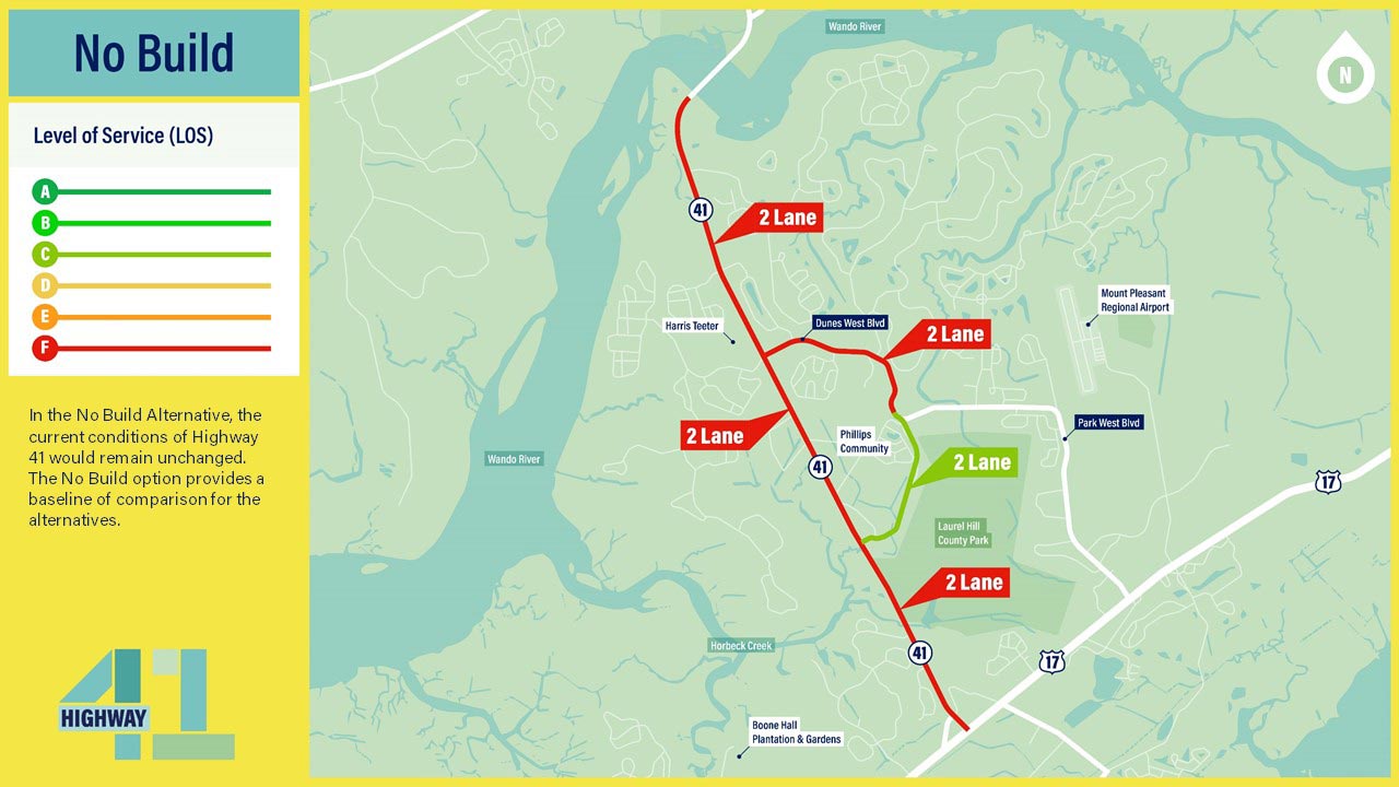
From the data gathered through environmental and cultural studies, a range of 12 alternatives was identified. Out of the 12 alternatives that were considered, three reasonable alternatives (#1, #2 and #7) plus a No Build option were carried forward for further analysis based on traffic performance and level of service for design year 2045.
Alternative 1 would consist of widening existing Highway 41 to a 5-lane roadway from Highway 17 to the Wando River Bridge. This alternative would include two lanes of traffic in each direction and a center turn lane. This alternative would provide an acceptable Level of Service and is moving forward for further evaluation.
 Click to enlarge
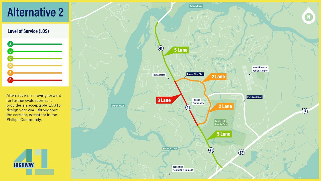
From the data gathered through environmental and cultural studies, a range of 12 alternatives was identified. Out of the 12 alternatives that were considered, three reasonable alternatives (#1, #2 and #7) plus a No Build option were carried forward for further analysis based on traffic performance and level of service for design year 2045.
Alternative 2 would consist of widening existing Highway 41 from two lanes to five lanes from Highway 17 to Joe Rouse Road. Highway 41 from Joe Rouse Road to Dunes West Boulevard would be widened to three lanes consisting of one travel lane in each direction with a center turn lane, and Highway 41 from Dunes West Boulevard to the Wando River Bridge would be widened to five lanes. This alternative is moving forward as it provides an acceptable Level of Service for design year 2045 throughout the corridor, except for in the Phillips Community.
 Click to enlarge
From the data gathered through environmental and cultural studies, a range of 12 alternatives was identified. Out of the 12 alternatives that were considered, three reasonable alternatives (#1, #2 and #7) plus a No Build option were carried forward for further analysis based on traffic performance and level of service for design year 2045.
Alternative 7 would establish a five lane roadway from Highway 17 to Bessemer Road. The five lane section would continue along Bessemer and Dunes West Boulevard to a five lane section on Highway 41 to the Wando River Bridge, making a continuous bypass around the Phillips Community. Existing Highway 41 would be widened to three lanes from Joe Rouse Road to Dunes West Boulevard through the Phillips Community. This alternative is moving forward for further evaluation.
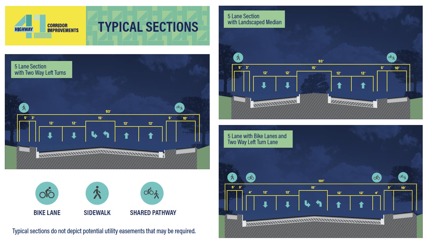
A new typical roadway with three lanes would include one travel lane in each direction with either a center turn lane or landscaped medians.
 Click to enlarge
A new typical roadway with five lanes would include two lanes of travel in each direction with either a center turn lane or landscaped medians.
 Click to enlarge
 Click to enlarge
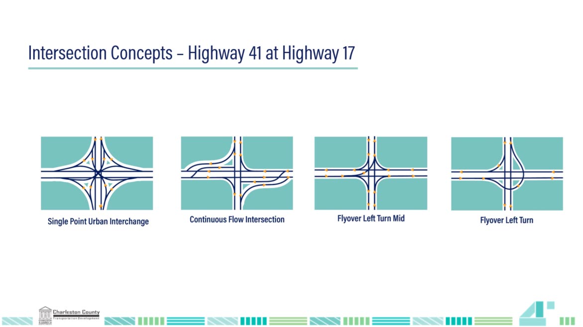
Single Point Urban Interchange - A single point urban interchange (SPUI) allows opposing left turns to proceed simultaneously by compressing the interchange into one single intersection under the free-flowing road. The term "single point" refers to the fact that all through traffic on the major street, as well as the traffic turning left onto or off the interchange, can be controlled from a single set of traffic signals. Due to the space efficiency of SPUIs relative to the volume of traffic they can handle, the interchange design is being used extensively in dense urban environments.
Continuous Flow Intersection - A continuous flow intersection (CFI) is an alternative design for an at-grade road intersection. Vehicles make a signal-protected turn across traffic cross before they enter the intersection. No left turn signal in the intersection is then necessary. Instead, vehicles traveling in both directions can proceed, including through vehicles and those turning right or left, when a traffic signal permits.
Flyover Left Turn Mid – In a Flyover Left Turn Mid intersection, vehicles would exit to the median to a flyover ramp/bridge that ties into outside lane of the intersecting roadway.
Flyover Left Turn – In a Flyover Left Turn intersection, vehicles would exit to the right to a flyover ramp/bridge that ties into the outside lane of the intersecting roadway.